LA Geo For All Lab Project
An LA county-wide, user-agency-centric amalgamation of the Geo for All initiative, advanced distributed learning (ADL), and business enterprise resource planning (ERP) into Informational communicational technological (ICT) operational open-source software systems. It's a practical framework with a modular functional toolkit for incorporating modern ICT resources based on open-source software systems and best practices from the CTCNet Start-up Manual for non-profits. The We Can Foundation/CalTekNet is programming a Digital Transformation.
What is the primary issue area that your application will impact?
Access to Creative Industry Employment (sponsored by Snap Foundation)
In which areas of Los Angeles will you be directly working?
Central LA
East LA
San Gabriel Valley
San Fernando Valley
South LA
West LA
South Bay
Antelope Valley
County of Los Angeles
City of Los Angeles
In what stage of innovation is this project, program, or initiative?
Applying a proven model or solution to a new issue or sector (e.g., using a job recruiting software or strategy to match clients to supportive housing sites, applying demonstrated strategies from advocating for college affordability to advocating for housing affordability and homelessness, etc.)
What is your understanding of the issue that you are seeking to address?
The issue stems from 2012 when the national CTCNet was disbanded after the last overall and first-time-ever annual conference held in LA. The conference was dominated by proprietary software company supporters and was blatantly highjacked. A collaborative digital divide network has not existed in support of shared resources, minimum program duplication, and community system best practices for the many agencies working to tackle the ever-growing and changing digital divide. In the ICT realm, we have paid for and used ESRI GIS proprietary software for the last few years. A government GIS Mapping expert volunteered with us and he convinced us that it was the best way to go. For 2 years now, we paid for account access and credits up front that expired before we used them. Our account is limited to basic applications that would require additional license fees to perform more than the basic analysis of data. We have lost maps from the previous year's work as they were on the ESRI portal.
Describe the project, program, or initiative this grant will support to address the issue.
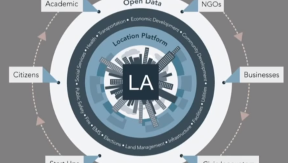
Lack of digital divide agencies' knowledge of, interest in, and ultimate evolution to incorporate more modern ICT systems. 2020 census data and ongoing releases of big data are not being leveraged by digital divide agencies in LA County. In most cases, proprietary software is the overwhelming choice of non-profits. There are no trends, that we know of, towards open-source adoption in digital divide agencies. Therefore, this project can produce a new trend. The Geo for All Initiative integrates many of the project's proposed components into a unified suite of open-source software applications. Furthermore, OSGeo's annual software distribution includes workshop data that are selected through a competitive submission process. The culmination and time of this project will include producing datasets that have the potential for being included in the 2023 workshop data distribution. The targeted organizations include: Former CTCNet Affiliates LA Advanced Distributed Learning ADL (US Government) California Education Network Infrastructure Corporation CENIC 501(c)3 LA City Neighborhood Councils LA County 211 Taxonomy ESRI Industries Health Transportation Textile Economics The profound processes Virtual Community Action Planning Work preference Indicator Applications OSGeo https://www.osgeo.org/choose-a-project/ Odoo ESRI
Describe how Los Angeles County will be different if your work is successful.
We are now mid-2022 and expect to utilize our maps differently. The move from proprietary software toward open source solutions is accelerating. Open source is more important than ever IT leaders are prioritizing enterprise open source over traditional solutions to meet challenges and build their infrastructure strategies Application categories traditionally dominated by proprietary applications are being replaced with open-source software, according to a new survey. IT leaders trust the security of open source 89% see enterprise open source as more secure or as secure as proprietary software This project will escalate and facilitate the appropriate adoption and integration of open-source software into the non-profit sectors. Furthermore, it will connect and facilitate collaborations between agencies their programs and constituencies
What evidence do you have that this project, program, or initiative is or will be successful, and how will you define and measure success?
We will create a baseline via polls, surveys, and personal communications. Making geospatial education and opportunities accessible to all in LA. “Geo for All” is the Open Source Geospatial Foundation’s Committee for Educational outreach and works in close collaboration with ICA, ISPRS, UN-GIS, AGILE, UCGIS, IGU, and other partners worldwide in our mission for making education and opportunities accessible to all. The move from proprietary software toward open source solutions is accelerating. Open source is more important than ever IT leaders are prioritizing enterprise open source over traditional solutions to meet challenges and build their infrastructure strategies We have and will continue to, aggregate, and make available mapped Geospatial datasets, grouped by urban and rural county geographic service regions which will be used to inform citizen science localized research engagement that entails, verifying, describing, and classifying information relating to community issues
Approximately how many people will be impacted by this project, program, or initiative?
Direct Impact: 400
Indirect Impact: 8,000