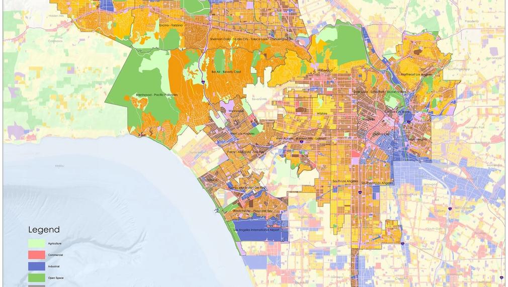
Crafting New Land Use and Zoning Policies: A Spatial Understanding of the Los Angeles Region
We're entering a crucial decade for both Los Angeles and the planet, decisionmakers and stakeholders need a comprehensive understanding of how land use, zoning, and code should change across our region to create places that produce both climate resilient outcomes and healthy communities. This project is an initial study into what regional land use, zoning, and code should look like while centering environmental and climate justice, public health, and racial inequities. We also seek to provide public education about land use and zoning concepts.

In which areas of Los Angeles will you be directly working?
County of Los Angeles
City of Los Angeles
What is the problem that you are seeking to address?
Like many coastal counties across the nation, Los Angeles County will be significantly impacted by climate change, not only from drought and fires, but sea-level rise and flooding, as well. Simultaneously, as we think about the not so distant future we are dealing with immediate crises such as segregation, urban warming, housing and homelessness, affordability and displacement, long commutes, and lack of tree canopy and green spaces to name a few. Unfortunately, most don’t understand how to utilize land use and zoning for a county as big as Los Angeles, there is no connected network of knowledge, data, and information to understand the inner workings of the region, and how land use and zoning decisions in one community ripple across the county to another. Thus, this project asks, for the 88 cities and unincorporated L.A. that make up the county, how should land use, zoning, and code be structured to create a county where every community is considered healthy from a holistic view?
Describe the project, program, or initiative that this grant will support to address the problem identified.
The project is best described using three phases (research and data gathering, crafting of the policy recommendation, and visualization and modeling) that are nested under one consistent phase (community engagement and outreach). Each phase is constructed through community engagement and outreach. Phase 1: Research and Data Gathering -> Literature Reviews, Focus Groups, Interviews, Data Collection, Data Analysis Phase 2: Crafting of Policy Recommendations -> Crafting model land use, zoning, code, setbacks, etc. to understand how to achieve what constitutes a healthy community Phase 3: Visualizing and Modeling -> Geospatial Modeling, Renderings Phase 4: Produce a Final Report We believe this is the appropriate phasing of the work as the land use and zoning decisions, the implications of those decisions, and the processes that lead to these decisions are so decentralized that they end up being inaccessible to communities across Los Angeles. This would be an opportunity to try and centralize those decisions, while also modeling and visualizing those decisions and how they not only reshape the spatial environment in the direct community and the broader region.
In what stage of innovation is this project, program, or initiative?
Research (initial work to identify and understand the problem)
Approximately how many people will be impacted by this project, program, or initiative?
Direct Impact: 2,500
Indirect Impact: 5,000
Describe how Los Angeles County will be different if your work is successful.
Short-Term Success 1. Laying the foundation to understand what needs to be done in broad strokes as it relates to land use, zoning, code, etc., across Los Angeles County 2. Creating a regional understanding of land use and zoning decisions 3. A public education campaign that helps people understand people, place, and biological diversity in the face of multiple crises that are playing out all at once. Changing how people can think of Los Angeles County and reimagine their spatial environment. We plan to change how people react to change in their community, and to get folks to see a future where they can all see themselves living in the communities they would like. Long-Term Success 1. Launching a new wave of civic engagement and community-led planning where people around Los Angeles County are working with local government to design and build communities that can meet the needs of all while understanding the broader ecosystem of place.
What evidence do you have that this project, program, or initiative is or will be successful, and how will you define and measure success?
Primary measure for success is will be determined using pre- and post-survey to measure change of attitudes and understanding of land use and zoning. 1. Success is getting people to realize that it’s not too late to solve the multitude of problems in society and the role of land use and zoning in helping to solve that 2. Success is getting people to understand the urban planning process as it relates to crafting the various land use and zoning policies in their communities, and how that then produces the spatial environments in which they live. Primary measure of success would be a complete report with an interactive map 3. Compiling a centralized way for people to understand how land use and zoning decisions interact with one another regionally. Long-term metric of success The long term metric be having land use and zoning decisions across the county in 88 cities and unincorporated Los Angeles produce healthy and climate resilient communities.
Which of the LIVE metrics will you impact?
Air quality
Resilient communities
Tree canopy cover
Indicate any additional LA2050 goals your project will impact.
LA is the best place to LEARN
LA is the healthiest place to CONNECT