Please describe the activation your organization seeks to launch.
Driving direction apps are ubiquitous, transit apps are not far behind, but what about that “last mile,” or the last few feet? Pedestrians (footed, wheeled and otherwise) are woefully neglected by mapping apps. Until now.
Using OpenSidewalk data schema, The Glue will develop an app for LA residents to crowd source the location and condition of sidewalks. With enough data, we will help users plan a trip that produces the best way forward for pedestrians of all types.
Which of the LIVE metrics will your activation impact?
Walk/bike/transit score
Will your proposal impact any other LA2050 goal categories?
LA is the best place to PLAY
In what areas of Los Angeles will you be directly working?
County of Los Angeles
City of Los Angeles
How will your activation mobilize Angelenos?
Digital organizing or activism
Trainings and/or in-person engagements
Create new tools or technologies for greater civic/political engagement
Describe in greater detail how your activation will make LA the best place to LIVE?
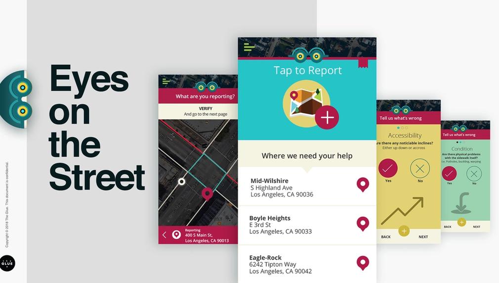
Using a schema called OpenSidewalk in partnership with The University of Washington’s Taskar Center for Accessible Technology, The Glue proposes developing an app for LA residents to crowdsource data on the location and condition of sidewalks during “mapathon” events as well as every day. This data will include accessibility concerns (width, incline, barriers, etc), general attributes (cleanliness, potholes, weeds, etc) as well as add local-specific attributes, shade hours for example. With enough data, we can help users plan a trip that produces the best way forward for pedestrians of all types.
We currently have a proprietary interactive prototype that we will use to build out into a fully functional initial app. In collaboration with the University of Washington we will establish a baseline pedestrian network, and then invite participants to validate and adjust individual areas. Functionality will include GPS tracking of data including barriers, incline, curbs, lighting, ramps, tactile paving, wheelchair access, amenities such as water fountains, benches, shelter, toilets and others. Additionally, we may implement camera width measurement and exact incline measurement by gyroscope.
Using this initial product, after thorough testing, we will design and hold ‘mapathon’ events centered around high density transit areas to gather data in initial large bursts. Using those learnings, we will refine the app if needed, as well as our incentivisation approach, and hold more mapathon events, as well as release the app for use in people’s everyday lives.
The data we generate will serve two important purposes. It will allow citizens to plan the best routes, end to end. It will also allow us to collect open-source information to add to LA’s on the condition of pedestrian access in and around the most dense and trafficked transit areas. This will help both public and private organizations to prioritize issues that may keep citizens from walking and using transit to its fullest.
The end result will have benefits that tie directly to improving LA’s walk, bike and transit score. If physical access to transit is easier to understand, as well as in better repair, that will increase transit use and ridership. Allowing citizens to find the most accessible route for them, especially for those in wheelchairs, with limited mobility, or simply pushing a stroller will enhance overall safety, making people feel better about getting outside and enjoying Los Angeles. Finally, simply the knowledge that “someone is listening” when citizens report problems goes a long way to instill faith and trust in civic organizations. These all contribute to our shared goal of a more livable and sustainable city.
More about the schema: https://www.opensidewalks.com/
Our prototype: https://invis.io/F2C8XR4HW#/239912225_Load
How will your activation engage Angelenos to make LA the best place to LIVE
For all of us who have walked around LA, it’s impossible not to notice the poor condition of our sidewalks. From buckled concrete, to lack of shade, to missing curb cuts to whole neighborhoods that don’t even have sidewalks, we’ve surrendered transportation to motorized vehicles. It is simply unpleasant to walk in many of LA’s neighborhoods. This steers people away from healthy walking lifestyles, as well as away from using transit because getting to the bus or rail station is difficult or unpleasant.
Multiply the above by ten for those with disabilities, older residents and people pushing strollers. They know that a buckled sidewalk can be anything from an inconvenience to a major catastrophe. And often these are the people who need our sidewalks the most.
In order for Eyes on the Street to gather good data, we need people to use the app! Once EotS is built, we hope LA2050 can help us encourage use of the app through Mapathon events, incentives and publicity. We want to reach out to a breadth of communities to gather data on their neighborhoods, especially those in “High Injury Networks.” Those areas often need the most infrastructure investment and the first step is understanding the current state of the sidewalks. Where The Glue brings the design and technical chops, we hope to partner with LA2050’s extensive community outreach and strategic partnerships to populate data.
Please explain how you will define and measure success for your activation.
Upon launch of the app we will choose five Los Angeles neighborhoods to hold Mapathon events, where we collect a lot of data together, and have fun doing it. Anyone with a smartphone will be able to download the app and get mapping, but it’s more effective if a large group targets particular neighborhoods.
Here’s a possible set of five. These locations are based on cross-referencing High Injury Network Spotlight Streets with Metro ridership data:
Koreatown: along Red Line and near MacArthur Park and Safe Routes to School designated areas
Highland Park: along Figueroa
Downtown LA: Historic Core, Jewelry District, Little Tokyo
South LA: alongI Main and Avalon and Safe Routes to School designated areas
Success will be achieved if we have collected enough data on these initial five neighborhoods to map safe pedestrian routes for each neighborhood.
Where do you hope this activation or your organization will be in five years?
In five years we hope our app is ubiquitous in gathering info for LA sidewalks, and mapping the best walking route is as easy as mapping a route by car. We'd like to also deploy the app for cities all over the US, and even the world, to help create a truly global way to way-find while walking.
At The Glue we hope to continue to build products that keep us and our planet healthy and connected, and fun while doing it.